 |
| Taken from: http://www.turiscolombia.com/mapas/sangil.gif |
In relation to the line of latitude and Greenwich meridian, San Gil is located to 6° 33' latitude north and in terms of West longitude is located to 73° 8'.
It is located in the Guanentina province and it is the capital of it. It is 145 kilometers long and its inter municipal limits are:
- North: Villanueva and Curiti municipalities.
- East: Curiti and Mogotes.
- South: Valle de San José and Paramo.
- West: Pinchote, Cabrera and Barichara.
According to the census conducted in the year 1993 the population of San Gil was of 35,123 inhabitants. According to the projected year 2005 there are 42,493 inhabitants, growing 614 people a year.
WHEATHER AND TOPOGRAPHY
Thanks to the height of the town, which is 1114m above the sea level, its temperature is between 24° and 32°. The rain regime is between 600 and 1800 millimeters per year with an average of 1200 millimeters making of April and May the months with greater precipitation during the first half of the year being the main harvest for people. September and October are months with precipitations making them a good season for mid-crop.
The 82,2% of land has a temperate thermal floor, which is warm climate, and only the 17,8% is medium climate.
The major part of this territory varies between wavy and strongly wavy. Its topography is characteristic of the eastern Andes range. Its mountains are raised to the north until the "Alto de la Legua" and continue until the lakes where it is located the airport to the height of 1750m. To the east, the range goes up to the "Alto del Mirador", which is the highest with a height of 2000m. To the west, the range goes up to the Guarigua region until the "Volador" limit to 1400 m. In the south, it is found mountains until the hight point of the plateau to 1800 meters high and goes down until the formation of the Fonce River.
San Gil has an aproximate area of 145.9 square kilometers, its equivalent in hectares is 14.950 in lands with topography with a flat surface, wavy and strongly wavy, and steeply grounds which are difficult to use in livestock and farming.
Source: http://www.sangil.com.co/generalidades.phpThe major part of this territory varies between wavy and strongly wavy. Its topography is characteristic of the eastern Andes range. Its mountains are raised to the north until the "Alto de la Legua" and continue until the lakes where it is located the airport to the height of 1750m. To the east, the range goes up to the "Alto del Mirador", which is the highest with a height of 2000m. To the west, the range goes up to the Guarigua region until the "Volador" limit to 1400 m. In the south, it is found mountains until the hight point of the plateau to 1800 meters high and goes down until the formation of the Fonce River.
San Gil has an aproximate area of 145.9 square kilometers, its equivalent in hectares is 14.950 in lands with topography with a flat surface, wavy and strongly wavy, and steeply grounds which are difficult to use in livestock and farming.
In the following map you are going to find the Touristic Map of San Gil:
 |
| Taken from: http://www.aventuratotal.com.co/planes.html |
2. Total Adventure
3. Cotrasangil
4. House of Culture and Archeologic Museum
5. Main Park
6. Market Place 'Plaza de Mercado'
7. Terminalito
8. Fique Museum
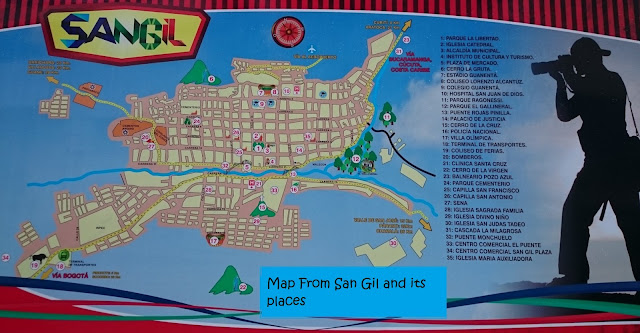
The following is a map in which you can see the most important places in San Gil:
 |
| Taken from San Gil Map, located at Lorenzo Alcantuz Stadium, by Andrea Santos, 2015. |
No comments:
Post a Comment